
Navigator Field
Eastern Shelf of Midland Basin
Burk-Gunn Oil Co.
Dickens County, Texas, USA
Producing reservoir
L Permian Tannehill Ss
Approximate depth below surface
1200 feet (365 m)
Development techniques
Subsurface geology, Exploration geochemistry, Dipmeter
Production to date
About 3 MMB Oil
Current status
Operated by Burk-Gunn Oil Co.
Navigator field was discovered using integrated modeling.
Geomorphology, subsurface geology, near-surface geochemistry, electric logs, sidewall cores, and FMS-FMI dipmeter played important roles in discovery and development of this stratigraphic sandstone oil reservoir.
Profile A-A' schematically shows integration results
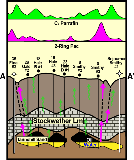
Findings of this study were:
• The complex sandstone reservoirs were variable thickness and discontinuous.
• Surface water channels (creeks) were apparent surface expressions of fractures or faults.
• Hydrocarbon conduction to the surface by fractures was indicated by high concentrations of 2-Ring PAC (as naphthalene) near field limits.
• C2 Paraffin (ethane) data showed high concentrations over apparent fractures and also elevated concentrations over the productive reservoir.
Details of this study were reported in "How Integrated Modeling Assisted with Navigator Find, Midland Basin Eastern Shelf. Click on the paper title or Contact Us for a free hardcopy reprint.
Reference: R. A. Cannon, G.K. Rice, and J. Q. Belt, Jr., 2001, "How Integrated Modeling Assisted with Navigator Find, Midland Basin Eastern Shelf", Oil & Gas Journal, July 9, 2001