Thistle Field
Shell Oil Company
Pecos County, Texas, USA
Producing reservoir
Caballos Novaculite
Approximate depth below surface
1800-2800 ft (550-850 m)
Production to date
About 4 BCF Gas, 3 MMB Oil
Current status
Operated by Sandridge Energy
Thistle Field is part of the Marathon Thrust Belt from which the field derives its complex geology.
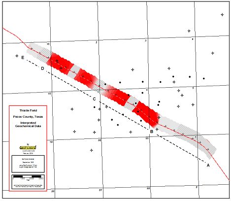
The Thistle field geochemical data was somewhat complex as shown on the Interpreted Geochemical Data map.

Geochemical data interpretation included hydrocarbon concentration (how much) and hydrocarbon composition (what kind, or fingerprint).
Hydrocarbon gases over reservoirs are expected to be above background concentrations.
• Concentration areas below background were colored crosshatched gray.
• Areas not matching the main composition were colored solid gray.
• Areas within the main composition range were colored red, therefore, areas with high (above background) hydrocarbon gas concentrations and within the main composition range were colored red.
• All other areas were colored shades of gray.
A dashed line divided into four lettered segments helps distinguish the four distinct parts of the interpreted sample line.
• Segment A-B at the southeast end of the sample line contained only samples meeting background criteria.
• Segment B-C, which matched extents of the current Thistle Field, exhibited a nearly ideal geochemical data pattern with only one sample in the background range.
• Segment C-D illustrated the geological complexity of the Thistle Field area. Alternating background and significant samples probably represented isolated petroleum compartments. Segment C-D was more discontinuous than productive Segment B-C.
• Segment D-E exhibited continuous background.
While this limited geochemical test data yielded positive results, gridded sample designs and closer sample spacing would make soil gas geochemistry a valuable Caballos exploration tool.
